Destructive winds and the potential for large hail and tornadoes are threatening the Plains this week as a potent severe weather system takes aim at the region, prompting urgent warnings and preparations.
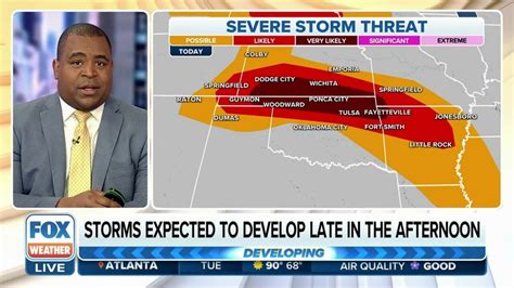
A multi-day severe weather outbreak is forecast to impact the central and southern Plains, beginning today and lasting through the week. The most immediate threat is high winds, with gusts potentially exceeding 75 mph in some areas, which could lead to widespread power outages, structural damage, and dangerous travel conditions. The Storm Prediction Center (SPC) has issued a Level 3 out of 5 “Enhanced Risk” for severe weather across portions of Kansas, Oklahoma, and Texas for today, indicating a heightened probability of significant severe weather events.
“A rather widespread wind damage threat is anticipated across much of western/central Kansas and western Oklahoma this afternoon and evening,” the SPC warned in its latest forecast discussion. This threat extends beyond just wind, however, as large hail and tornadoes are also possible, particularly in the afternoon and evening hours.
The severe weather threat is being driven by a strong upper-level disturbance interacting with a highly unstable air mass over the Plains. Warm, moist air surging northward from the Gulf of Mexico is clashing with cooler, drier air from the north, creating the perfect conditions for the development of severe thunderstorms. The strong winds aloft are also contributing to the potential for rotating thunderstorms, known as supercells, which are capable of producing tornadoes.
Beyond today, the severe weather threat is expected to shift eastward, impacting areas further east and south. The SPC is already highlighting the potential for severe weather across parts of the Mississippi Valley and the Southeast later in the week, meaning residents throughout a large swath of the country should remain vigilant and monitor weather forecasts closely.
According to weather.com, the atmosphere will remain primed for more rounds of severe thunderstorms across the Plains into midweek. A potent upper-level trough of low pressure will stall over the region, keeping the ingredients for severe weather in place.
The National Weather Service (NWS) is urging residents in the affected areas to take precautions, including securing loose objects, having a plan in case of a tornado, and staying informed about the latest weather updates. Power outages are a significant concern, so it is advisable to have a backup power source and emergency supplies on hand.
The severity of this week’s weather threat is a stark reminder of the power of nature and the importance of preparedness. With potentially destructive winds, large hail, and tornadoes possible, residents across the Plains and beyond should take this threat seriously and take steps to protect themselves and their property.
This event underscores the importance of having multiple ways to receive weather alerts, including NOAA Weather Radio, smartphone apps, and local television and radio broadcasts. It is also crucial to understand the difference between a severe thunderstorm watch and a severe thunderstorm warning, as well as a tornado watch and a tornado warning, and to know what actions to take in each situation.
In-Depth Analysis
The current severe weather outbreak is not an isolated event, but rather part of a larger pattern of increasingly frequent and intense severe weather events across the United States. Climate change is believed to be a contributing factor, as warmer temperatures and increased atmospheric moisture can create more favorable conditions for severe thunderstorm development. While it is difficult to attribute any single weather event directly to climate change, the overall trend is clear: severe weather is becoming more common and more intense in many parts of the country.
The location of this week’s severe weather outbreak, the central and southern Plains, is particularly vulnerable to these types of events. The Plains are a flat, open area with a high degree of temperature and moisture contrast, making it a breeding ground for severe thunderstorms. The region is also prone to tornadoes, as the strong winds aloft can easily spin up into rotating thunderstorms.
The timing of this week’s event is also noteworthy. While severe weather can occur at any time of year, it is most common in the spring and early summer months. This is because the atmosphere is typically more unstable during this time of year, as warm, moist air from the Gulf of Mexico collides with cooler, drier air from the north.
The combination of all of these factors makes this week’s severe weather outbreak a potentially dangerous event. Residents in the affected areas should take precautions and stay informed about the latest weather updates.
Background Information
Severe weather is defined as any weather phenomenon that poses a threat to life or property. This can include thunderstorms, tornadoes, hail, high winds, and flooding. Severe thunderstorms are characterized by the presence of large hail (1 inch in diameter or greater), damaging winds (58 mph or greater), or tornadoes.
Tornadoes are violently rotating columns of air that extend from a thunderstorm to the ground. They are one of the most destructive forces of nature, capable of causing widespread damage and death. Tornadoes are most common in the United States, particularly in the central and southern Plains, an area known as “Tornado Alley.”
Hail is another common type of severe weather. It is formed when raindrops freeze high in the atmosphere and then grow larger as they collect more water. Hail can cause significant damage to crops, cars, and homes.
High winds are also a significant threat during severe weather events. Strong winds can topple trees, damage buildings, and cause power outages.
Flooding is another serious hazard associated with severe weather. Heavy rainfall can overwhelm drainage systems and cause rivers and streams to overflow their banks. Flooding can cause significant damage to property and can also be life-threatening.
Expanded Context
The impact of severe weather can be devastating, both economically and socially. Severe weather events can cause billions of dollars in damage and can disrupt lives for weeks, months, or even years.
The economic impact of severe weather includes damage to property, crops, and infrastructure. It also includes the cost of emergency response, cleanup, and recovery.
The social impact of severe weather includes displacement, injury, and death. It also includes the psychological trauma that can result from experiencing a severe weather event.
In order to mitigate the impact of severe weather, it is important to have effective warning systems in place. These systems should provide timely and accurate information about the potential for severe weather so that people can take precautions.
It is also important to have building codes and regulations that are designed to withstand severe weather. These codes should require buildings to be constructed in a way that can withstand high winds, hail, and flooding.
Finally, it is important to educate people about the dangers of severe weather and how to protect themselves. This education should include information about how to recognize the signs of severe weather, how to take shelter, and how to prepare for a severe weather event.
Quotes
- “A rather widespread wind damage threat is anticipated across much of western/central Kansas and western Oklahoma this afternoon and evening,” the Storm Prediction Center warned.
- According to weather.com, the atmosphere will remain primed for more rounds of severe thunderstorms across the Plains into midweek.
FAQ
-
What areas are most at risk for severe weather this week?
The central and southern Plains are at the highest risk, specifically portions of Kansas, Oklahoma, and Texas. The threat is expected to shift eastward later in the week, potentially impacting parts of the Mississippi Valley and the Southeast. It’s crucial to monitor local forecasts if you live in these regions.
-
What kind of severe weather is expected?
The primary threats include destructive winds (potentially exceeding 75 mph), large hail, and tornadoes. The Storm Prediction Center has issued an “Enhanced Risk” (Level 3 out of 5) for severe weather in some areas, indicating a heightened probability of significant events.
-
What precautions should I take?
Secure loose objects around your home, have a plan in case of a tornado (know where to take shelter), and stay informed about the latest weather updates. Consider having a backup power source and emergency supplies on hand in case of power outages. Have multiple ways to receive weather alerts, such as NOAA Weather Radio, smartphone apps, and local media.
-
What is the difference between a severe thunderstorm watch and a severe thunderstorm warning?
A severe thunderstorm watch means that conditions are favorable for severe thunderstorms to develop in the watch area. It’s a time to be alert and monitor the weather. A severe thunderstorm warning means that a severe thunderstorm has been detected and is posing an immediate threat to the area. Seek shelter immediately if a warning is issued for your location. The same logic applies to tornado watches and warnings.
-
Is climate change contributing to these severe weather events?
While it’s difficult to attribute any single weather event directly to climate change, the overall trend shows that severe weather is becoming more frequent and intense in many parts of the country. Warmer temperatures and increased atmospheric moisture, both influenced by climate change, can create more favorable conditions for severe thunderstorm development.
Detailed Expansion on Severe Weather Elements
-
Destructive Winds: The primary concern highlighted by forecasters is the potential for widespread destructive winds. These winds, potentially gusting over 75 mph, can cause significant damage. Trees can be uprooted, power lines downed, and structures damaged. Mobile homes are particularly vulnerable in high-wind situations. The risk extends beyond rural areas, as urban environments can also experience falling debris and damage to infrastructure. The force of these winds can also make driving extremely hazardous, especially for high-profile vehicles.
-
Large Hail: Hailstones, defined as being 1 inch in diameter or larger, are capable of causing considerable damage. They can shatter windows, dent vehicles, and damage roofs. Farmers are particularly concerned about the impact of large hail on crops, potentially leading to significant agricultural losses. The size of hailstones is dependent on the strength and duration of updrafts within a thunderstorm. The stronger the updraft, the larger the hailstones that can be suspended and grow before falling to the ground.
-
Tornadoes: While the threat of widespread tornadoes is not explicitly emphasized, the potential for rotating thunderstorms (supercells) suggests a heightened risk. Tornadoes are violently rotating columns of air that can cause catastrophic damage. They are notoriously difficult to predict with pinpoint accuracy, making preparedness and awareness crucial. Supercell thunderstorms, with their rotating updrafts (mesocyclones), are the most common producers of tornadoes.
Impact on Infrastructure and Society
-
Power Outages: Destructive winds are a major cause of power outages. Downed power lines can disrupt electricity service to homes, businesses, and critical infrastructure. Prolonged power outages can have cascading effects, impacting everything from food spoilage to the functioning of hospitals and emergency services.
-
Transportation Disruptions: High winds and heavy rainfall can make driving conditions extremely dangerous. Reduced visibility, flooded roadways, and the risk of falling debris can lead to accidents and traffic delays. Air travel can also be disrupted, with flight cancellations and delays common during severe weather events.
-
Agricultural Losses: Farmers are particularly vulnerable to the impacts of severe weather. Hail can decimate crops, while high winds can damage or destroy agricultural structures. Prolonged periods of flooding can also ruin crops and impact livestock.
-
Emergency Response: Severe weather events can strain emergency response resources. First responders may be called upon to rescue people from flooded areas, provide medical assistance to the injured, and clear debris from roadways. Effective communication and coordination are essential to ensure an efficient and timely response.
Long-Term Recovery and Mitigation
-
Building Codes and Construction Practices: Communities in areas prone to severe weather should adopt building codes that require structures to be built to withstand high winds and hail. This may include reinforcing roofs, using impact-resistant windows, and anchoring structures to their foundations.
-
Infrastructure Improvements: Investing in infrastructure improvements, such as upgrading power grids and improving drainage systems, can help to mitigate the impacts of severe weather. Burying power lines underground can reduce the risk of outages caused by high winds.
-
Community Preparedness Programs: Community preparedness programs can help to educate residents about the risks of severe weather and how to prepare for these events. These programs can include training on how to recognize the signs of severe weather, how to take shelter, and how to assemble emergency kits.
-
Climate Change Mitigation and Adaptation: Addressing climate change is essential to reducing the long-term risk of severe weather. This includes reducing greenhouse gas emissions and adapting to the impacts of climate change that are already being felt.
The Role of Technology in Forecasting and Communication
-
Advanced Weather Models: Meteorologists rely on sophisticated computer models to forecast severe weather. These models use data from a variety of sources, including satellites, radar, and surface observations, to predict the development and movement of thunderstorms.
-
Doppler Radar: Doppler radar is a powerful tool for detecting and tracking severe thunderstorms. It can measure the speed and direction of wind within a storm, allowing meteorologists to identify rotating thunderstorms that may produce tornadoes.
-
Satellite Imagery: Satellite imagery provides a broad overview of weather patterns and can be used to identify areas of instability that may lead to severe weather.
-
Mobile Technology: Mobile technology has revolutionized the way people receive weather alerts. Smartphone apps can provide real-time weather information and warnings, allowing people to take action quickly when severe weather threatens.
Psychological Impact of Severe Weather Events
The experience of living through a severe weather event can be traumatic, leading to anxiety, stress, and even post-traumatic stress disorder (PTSD). The loss of property, the fear for one’s safety, and the disruption to daily life can all take a toll on mental health. It is important to provide support and resources to those who have been affected by severe weather events. This may include counseling, support groups, and access to mental health services. The repeated exposure to news and imagery of severe weather can also contribute to anxiety, highlighting the importance of managing media consumption during these events.
Detailed Steps for Preparing for a Severe Weather Event
-
Develop a Family Emergency Plan: A well-defined family emergency plan is the cornerstone of preparedness. This plan should outline what to do before, during, and after a severe weather event. It should include designated meeting places, evacuation routes, and communication strategies. Make sure everyone in the family understands the plan and practices it regularly.
-
Assemble an Emergency Kit: An emergency kit should contain essential supplies to help you survive for at least three days without outside assistance. This kit should include:
- Water: One gallon of water per person per day.
- Food: Non-perishable food items, such as canned goods, granola bars, and dried fruit.
- First-aid kit: A comprehensive first-aid kit with bandages, antiseptic wipes, pain relievers, and any necessary prescription medications.
- Flashlight and batteries: A reliable flashlight with extra batteries.
- Battery-powered or hand-crank radio: To receive weather updates in case of power outages.
- Whistle: To signal for help.
- Dust mask: To protect against contaminated air.
- Moist towelettes, garbage bags, and plastic ties: For personal sanitation.
- Wrench or pliers: To turn off utilities if necessary.
- Can opener: For canned food.
- Local maps: In case GPS is unavailable.
- Cell phone with chargers and a backup battery.
-
Secure Your Home: Take steps to secure your home before a severe weather event. This includes:
- Bringing in outdoor furniture, decorations, and other loose objects.
- Trimming trees and shrubs to prevent branches from falling on your home.
- Cleaning gutters and downspouts to ensure proper drainage.
- Reinforcing garage doors, which are often vulnerable to high winds.
- Consider installing storm shutters or covering windows with plywood.
-
Stay Informed: Monitor weather forecasts regularly and be aware of any watches or warnings that have been issued for your area. Use multiple sources of information, such as NOAA Weather Radio, smartphone apps, and local media.
-
Know Where to Take Shelter: Identify safe places to take shelter in your home and in your community. In the event of a tornado, the safest place to be is in a basement or storm cellar. If you don’t have access to a basement or storm cellar, go to an interior room on the lowest level of your home, away from windows and doors. In a public building, follow the instructions of emergency personnel.
-
Practice Your Plan: Regularly practice your family emergency plan so that everyone knows what to do in the event of a severe weather event. This will help to reduce anxiety and ensure that you are prepared to take action quickly when necessary.
-
Review Insurance Coverage: Understand your homeowner’s or renter’s insurance policy, including what it covers in the event of severe weather damage. Know your deductibles and how to file a claim. Document your belongings with photos or videos, which can be helpful when filing an insurance claim after a disaster. Consider flood insurance if you live in an area prone to flooding, as standard homeowner’s policies typically do not cover flood damage.
By taking these steps, you can significantly increase your safety and preparedness for severe weather events.