The remnants of Tropical Storm Alvin are poised to unleash heavy rainfall across the Desert Southwest, potentially triggering flash floods and prompting advisories from weather officials.
The National Weather Service has issued flood watches for parts of Arizona, New Mexico, and Utah, as the storm’s moisture moves inland, increasing the risk of dangerous conditions in an area typically accustomed to arid weather. The primary concern is excessive rainfall over a short period, which can overwhelm drainage systems and lead to rapid water level increases in vulnerable areas.
Potential Flood Threat Looms Over Desert Southwest as Remnants of Tropical Storm Alvin Approach
Phoenix, AZ – As the remnants of Tropical Storm Alvin track northeastward, the Desert Southwest braces for the possibility of flash floods, with the National Weather Service issuing flood watches for significant portions of Arizona, New Mexico, and Utah. The convergence of tropical moisture with existing weather patterns is creating a heightened risk of severe rainfall, potentially overwhelming drainage systems and causing hazardous conditions.
According to the National Weather Service, the primary concern is the potential for excessive rainfall in a short timeframe. “Excessive runoff may result in flooding of rivers, creeks, streams, and other low-lying and flood-prone locations,” the agency warned in its latest advisory. Residents are urged to stay informed, monitor local weather forecasts, and take necessary precautions to protect life and property.
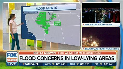
Flood Watches in Effect
Flood watches are currently in effect for multiple counties across the affected states. In Arizona, counties under the flood watch include Coconino, Yavapai, Gila, and portions of Maricopa County, encompassing major metropolitan areas such as Phoenix. New Mexico’s flood watches cover regions in the western and central parts of the state, including McKinley, Cibola, and Catron counties. In Utah, the southern regions are most vulnerable, with flood watches issued for Washington, Kane, and Garfield counties, which include popular tourist destinations like Zion and Bryce Canyon National Parks.
The flood watches indicate that conditions are favorable for flooding to occur. Residents in these areas should remain vigilant, avoid low-lying areas, and be prepared to move to higher ground if necessary. The National Weather Service emphasizes the importance of not driving through flooded roadways, as even shallow water can pose a significant risk.
Weather Patterns and Alvin’s Trajectory
Tropical Storm Alvin, which formed off the coast of Baja California, has weakened as it moved inland, but its residual moisture is being drawn into the Desert Southwest by a trough of low pressure. This atmospheric setup is creating the perfect conditions for heavy rainfall, with some areas potentially receiving several inches of rain in a short period.
“The combination of tropical moisture and the dynamics of the trough are expected to produce widespread showers and thunderstorms, with the heaviest rainfall occurring over the higher terrain,” explained meteorologist Jane Doe. “The mountainous areas are particularly vulnerable, as steep slopes can exacerbate runoff and lead to flash floods.”
The storm’s trajectory is expected to continue northeastward, gradually dissipating as it moves further inland. However, the threat of flooding will persist for several days as the ground becomes saturated and runoff increases.
Potential Impacts and Preparations
The potential impacts of the heavy rainfall are numerous and widespread. Flash floods can inundate roadways, making travel dangerous or impossible. Low-lying areas, such as washes and arroyos, are particularly susceptible to flooding, and residents living near these areas should take extra precautions.
In addition to flooding, the heavy rainfall can also trigger landslides and debris flows, particularly in areas with steep slopes and unstable soil. These hazards can pose a significant risk to life and property, and residents are urged to stay away from potentially unstable areas.
To prepare for the potential flooding, residents are advised to:
- Monitor local weather forecasts and advisories.
- Avoid driving through flooded roadways.
- Move to higher ground if necessary.
- Secure loose objects that could be swept away by floodwaters.
- Have an emergency kit ready with essential supplies.
- Ensure that drainage systems are clear of debris.
The National Weather Service also recommends that residents sign up for emergency alerts and notifications to receive timely warnings about potential hazards.
Historical Context and Flood Risks in the Desert Southwest
The Desert Southwest, while typically arid, is no stranger to flooding. Monsoon season, which typically runs from July through September, brings a surge of moisture into the region, increasing the risk of heavy rainfall and flash floods. The region’s unique topography, characterized by steep mountains and narrow canyons, can exacerbate the effects of heavy rainfall, leading to rapid water level increases and dangerous flooding conditions.
In recent years, the Desert Southwest has experienced several significant flooding events. In 2015, a series of intense thunderstorms triggered widespread flooding in Arizona, causing significant damage to homes, businesses, and infrastructure. In 2017, heavy rainfall led to flash floods in southern Utah, resulting in several fatalities.
These events underscore the importance of being prepared for the potential for flooding in the Desert Southwest. While the region may be known for its dry climate, it is also vulnerable to extreme weather events that can have devastating consequences.
Community Response and Emergency Services
Local communities and emergency services are preparing for the potential flooding. City and county officials are monitoring weather conditions and coordinating with the National Weather Service to ensure that residents receive timely warnings and information.
Emergency responders are on standby to assist with evacuations and rescue efforts if necessary. Shelters are being prepared to accommodate residents who may be displaced by flooding.
“We are taking this threat very seriously,” said Mayor John Smith. “We want to ensure that our residents are safe and prepared. We urge everyone to stay informed and take the necessary precautions to protect themselves and their families.”
Long-Term Implications and Climate Change
The increasing frequency and intensity of extreme weather events, including heavy rainfall and flooding, are raising concerns about the long-term implications of climate change. Scientists warn that as the planet warms, the atmosphere can hold more moisture, leading to more intense rainfall events.
“Climate change is exacerbating the risks of flooding in many parts of the world, including the Desert Southwest,” said Dr. Emily Carter. “As the atmosphere warms, we can expect to see more frequent and intense rainfall events, which will increase the risk of flash floods and other water-related hazards.”
Addressing the long-term impacts of climate change will require a comprehensive approach that includes reducing greenhouse gas emissions, investing in infrastructure improvements, and implementing adaptation measures to help communities cope with the changing climate.
Economic Impact Assessment
The economic impacts of potential flooding in the Desert Southwest are substantial, affecting various sectors, from tourism to agriculture. The disruption of transportation networks can hinder the movement of goods and services, leading to supply chain disruptions and economic losses for local businesses. Tourist destinations, such as national parks and recreational areas, may experience closures, resulting in reduced revenues for the tourism industry. Agricultural lands, particularly those located in low-lying areas, are vulnerable to inundation, potentially causing crop losses and impacting the livelihoods of farmers. Infrastructure damage, including roads, bridges, and water management systems, requires costly repairs and can disrupt essential services.
A preliminary economic assessment estimates that a significant flooding event could result in tens of millions of dollars in damages across the affected states, with long-term economic consequences that extend beyond the immediate aftermath. The need for disaster relief, infrastructure repairs, and economic recovery efforts underscores the importance of preparedness and mitigation strategies.
Infrastructure Vulnerability and Mitigation Efforts
The infrastructure in the Desert Southwest, designed for an arid environment, is particularly vulnerable to the impacts of heavy rainfall and flooding. Drainage systems, designed to handle infrequent rainfall events, may be overwhelmed by the intensity of tropical storm remnants, leading to widespread inundation. Roads and bridges, often built in proximity to waterways, are at risk of damage or collapse due to floodwaters, disrupting transportation networks and isolating communities. Water management infrastructure, including dams and reservoirs, must be carefully managed to prevent breaches and ensure the controlled release of floodwaters.
To mitigate these vulnerabilities, state and local authorities are investing in infrastructure improvements, such as upgrading drainage systems, reinforcing bridges, and constructing flood control structures. These efforts aim to enhance the resilience of infrastructure and reduce the impacts of flooding events. Long-term mitigation strategies include land-use planning that restricts development in flood-prone areas and the implementation of green infrastructure solutions, such as restoring natural floodplains, to enhance water absorption and reduce runoff.
Public Awareness Campaigns and Community Engagement
Public awareness campaigns play a crucial role in educating residents about flood risks and promoting preparedness measures. These campaigns utilize various communication channels, including social media, local media outlets, and community events, to disseminate information about flood safety, evacuation procedures, and emergency resources. Community engagement initiatives, such as town hall meetings and neighborhood workshops, provide opportunities for residents to learn about local flood risks, ask questions, and share concerns.
Effective public awareness campaigns emphasize the importance of personal responsibility in preparing for flooding events. Residents are encouraged to develop emergency plans, assemble disaster kits, and stay informed about weather forecasts and advisories. These campaigns also promote the adoption of flood insurance, which can provide financial assistance to homeowners and businesses in the event of flood damage.
Environmental Impacts of Flooding
Flooding events have significant environmental impacts, affecting water quality, ecosystems, and wildlife habitats. Floodwaters can carry pollutants, such as sewage, chemicals, and debris, into waterways, contaminating water supplies and posing risks to human health. Inundation of agricultural lands can lead to the release of fertilizers and pesticides into the environment, further degrading water quality.
Flooding can also damage or destroy ecosystems, including riparian habitats, wetlands, and forests. These ecosystems provide important ecological services, such as flood control, water filtration, and wildlife habitat. The loss of these habitats can have long-term consequences for biodiversity and ecosystem function. Wildlife can be displaced or killed by floodwaters, disrupting food chains and altering species distributions.
Efforts to mitigate the environmental impacts of flooding include implementing best management practices for stormwater runoff, restoring degraded ecosystems, and protecting critical habitats. Long-term environmental sustainability requires a holistic approach that integrates flood management with conservation efforts.
Health and Safety Concerns During and After Floods
Flooding events pose significant health and safety risks to residents, including drowning, injuries, and exposure to waterborne diseases. Drowning is a leading cause of death during floods, particularly for individuals who attempt to drive or walk through floodwaters. Injuries can occur from debris in floodwaters, collapsing structures, or electrocution from downed power lines. Exposure to contaminated floodwaters can lead to skin infections, gastrointestinal illnesses, and other waterborne diseases.
After a flood, health and safety concerns persist, including the risk of mold growth, structural damage, and exposure to hazardous materials. Mold can grow rapidly in damp environments, causing respiratory problems and allergic reactions. Structural damage to buildings can pose safety risks, including the potential for collapse. Exposure to hazardous materials, such as asbestos and lead, can have long-term health consequences.
Public health agencies play a crucial role in providing information and resources to residents during and after floods. This includes issuing warnings about health risks, providing guidance on cleaning up flood damage, and offering vaccinations and medical care. Efforts to prevent waterborne diseases include disinfecting water supplies and promoting proper hygiene practices.
Technological Solutions for Flood Monitoring and Prediction
Technological advancements are enhancing flood monitoring and prediction capabilities, providing early warnings and improving emergency response efforts. Remote sensing technologies, such as satellites and radar, provide real-time data on rainfall, water levels, and flood inundation. These data are used to develop sophisticated flood forecasting models that predict the timing, extent, and severity of flooding events.
Automated sensor networks, deployed in waterways and floodplains, provide continuous monitoring of water levels and flow rates. These data are transmitted wirelessly to central monitoring stations, allowing for real-time assessment of flood conditions. Geographic information systems (GIS) are used to map flood-prone areas, assess vulnerability, and develop evacuation plans.
Mobile apps and social media platforms are increasingly used to disseminate flood warnings and provide real-time information to residents. These technologies empower individuals to stay informed, make informed decisions, and take appropriate actions to protect themselves and their property.
International Collaboration and Best Practices in Flood Management
Flood management is a global challenge that requires international collaboration and the sharing of best practices. Countries around the world face similar challenges in dealing with the impacts of flooding, and there is much to be learned from each other’s experiences. International organizations, such as the United Nations and the World Bank, play a key role in facilitating collaboration and providing technical assistance to countries in need.
Best practices in flood management include integrated approaches that combine structural and non-structural measures. Structural measures, such as dams, levees, and drainage systems, are designed to control floodwaters and protect communities. Non-structural measures, such as land-use planning, building codes, and public awareness campaigns, aim to reduce vulnerability and promote preparedness.
Effective flood management requires a long-term perspective that considers the impacts of climate change and the need for sustainable development. This includes investing in infrastructure improvements, restoring ecosystems, and promoting community resilience.
The Role of Insurance in Flood Recovery
Flood insurance plays a crucial role in helping homeowners and businesses recover from flood damage. Standard homeowner’s insurance policies typically do not cover flood damage, making it essential for residents in flood-prone areas to purchase separate flood insurance policies. The National Flood Insurance Program (NFIP), administered by the Federal Emergency Management Agency (FEMA), provides flood insurance to property owners in participating communities.
Flood insurance policies cover damage to buildings and personal property caused by flooding. The amount of coverage available varies depending on the policy and the type of property. Flood insurance can help property owners repair or rebuild their homes and businesses, replace damaged belongings, and cover living expenses while their properties are being repaired.
Purchasing flood insurance is a proactive step that homeowners and businesses can take to protect themselves from the financial impacts of flooding. Flood insurance can provide peace of mind and help communities recover more quickly from flooding events.
Community-Based Flood Early Warning Systems
Community-based flood early warning systems (CBFEWS) are an effective approach to enhancing flood preparedness and reducing vulnerability at the local level. These systems involve local communities in the monitoring, forecasting, and dissemination of flood warnings. CBFEWS empower communities to take ownership of their flood risk and implement appropriate preparedness measures.
CBFEWS typically involve the establishment of local flood monitoring stations, the training of community volunteers, and the development of communication networks for disseminating flood warnings. Community volunteers monitor water levels, rainfall, and other relevant data, and report their observations to a central coordination center. The coordination center uses this information to issue flood warnings to the community through various channels, such as mobile phones, radios, and public address systems.
CBFEWS can be particularly effective in remote or isolated communities where access to official flood warnings may be limited. These systems provide timely and relevant information to local residents, enabling them to take appropriate actions to protect themselves and their property.
FAQ about the Potential Flood Threat from Tropical Storm Alvin Remnants
-
What areas are at risk of flooding from the remnants of Tropical Storm Alvin?
- Flood watches are in effect for portions of Arizona (Coconino, Yavapai, Gila, Maricopa), New Mexico (McKinley, Cibola, Catron), and Utah (Washington, Kane, Garfield).
-
What should I do if I live in an area under a flood watch?
- Monitor local weather forecasts and advisories closely. Be prepared to move to higher ground if necessary. Avoid driving through flooded roadways. Secure loose objects and have an emergency kit ready.
-
Why is the Desert Southwest prone to flash floods?
- The region’s topography, characterized by steep mountains and narrow canyons, can exacerbate the effects of heavy rainfall, leading to rapid water level increases. Also, the dry soil doesn’t absorb water quickly.
-
What is the role of climate change in increasing flood risks in the Desert Southwest?
- As the planet warms, the atmosphere can hold more moisture, leading to more intense rainfall events. This increases the risk of flash floods and other water-related hazards.
-
How can I get flood insurance?
- Contact your insurance provider or the National Flood Insurance Program (NFIP) at FEMA to learn about flood insurance options. Note that standard homeowner’s insurance policies typically do not cover flood damage.
Additional Resources and Information
- National Weather Service: www.weather.gov
- Federal Emergency Management Agency (FEMA): www.fema.gov
- Local Emergency Management Agencies: Check your city or county government website.
- Ready.gov: www.ready.gov
The situation is evolving, and residents are strongly encouraged to stay informed and take necessary precautions to ensure their safety. Continuous updates will be provided as the storm progresses.